A major stratospheric wind reversal is now showing up in the latest weather models, and forecasters are watching closely. The signal is clear — a final collapse of the polar vortex appears to be underway as the world heads into March 2026. For millions of people across the United States, Canada, and Europe, this could mean a dramatic shift in winter conditions, just when spring felt like it was around the corner.
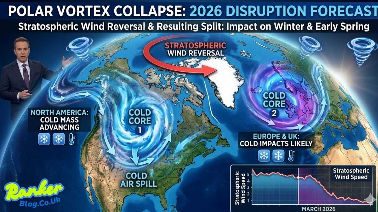
This forecasted disruption is expected to trigger a full polar vortex split, dividing the high-altitude circulation into two distinct cores. One of those broken cores is tracking toward North America, keeping a colder airmass locked close to the US and Canada, with cold spills already appearing in the extended forecast. The other core drifts toward Europe, including the UK, where cold air impacts may also be felt.
In this article, the focus is on breaking down the upcoming stratospheric wind reversal, the full polar vortex collapse, the resulting split, and what all of it means for weather across North America and Europe as a disrupted circulation continues into early Spring.
What Is a Polar Vortex — and Why Does It Matter?
Before diving into the forecast details, it helps to understand what a polar vortex actually is. The polar vortex is a large area of low pressure and cold air that surrounds the Earth’s poles. It exists high up in the stratosphere, roughly 10 to 50 kilometers above the surface, and acts like a spinning top — when it’s strong and tight, it keeps frigid Arctic air locked near the poles. When it weakens or breaks down, that cold air can escape southward into the mid-latitudes.
A polar vortex disruption doesn’t happen overnight, and it doesn’t affect surface weather immediately. The signal typically takes two to six weeks to work its way down from the stratosphere to the lower atmosphere where people actually live. That’s exactly why forecasters get excited — and concerned — when they spot one developing in the models.
Polar Vortex Stratospheric Warming: The Trigger Behind This Collapse
At the heart of this developing situation is a sudden stratospheric warming event. Sudden stratospheric warming (SSW) occurs when temperatures in the stratosphere spike rapidly — sometimes by 30 to 50 degrees Celsius within just a few days. This warming disrupts and weakens the polar vortex, slowing its circulation and, in more significant cases, reversing the stratospheric winds entirely.
The polar vortex stratospheric warming signal now showing in models is described by analysts as robust. The warming event is expected to cause a sharp polar vortex slowdown, and the current forecast trajectory suggests this slowdown will not stop there. The circulation is expected to break down more completely, leading to the full collapse and eventual split that models are now projecting.
This kind of stratospheric warming has a track record. Historical events — like the major SSW of January 2021 and the famous Beast from the East event in 2018 — showed exactly how powerful downstream weather impacts can be when the polar vortex stratospheric warming signal is this strong.
Polar Vortex Slowdown Forecast: Reading the Latest Models
The polar vortex slowdown forecast is what first caught the attention of meteorologists watching the upper atmospheric data. Over recent weeks, model data has consistently shown a deceleration of the stratospheric polar vortex. Wind speeds around the polar vortex, which normally flow from west to east at high speeds, are slowing significantly.
The polar vortex slowdown forecast as of this writing shows winds continuing to decelerate through late February and into early March. Once those winds drop to near zero and reverse direction, the event crosses the threshold into a full sudden stratospheric warming — a confirmed signal for downstream disruption.
Forecasters note that the polar vortex slowdown is being reinforced by a ridge of high pressure building over the polar regions, which is compressing and disrupting the vortex from above and below. This two-pronged squeeze is accelerating the breakdown that models are now projecting.
Polar Vortex Disruption January 2026: Setting the Stage
To understand what’s happening now, it’s worth looking back at the polar vortex disruption January 2026 brought. Earlier this winter, the vortex showed signs of stress. A less dramatic disruption in January weakened the circulation and contributed to cold outbreaks that affected parts of North America and Europe during that period.
That January disruption is now being viewed as a precursor. Rather than fully recovering, the polar vortex appeared to limp along in a weakened state before the current, more powerful stratospheric warming event began developing. This context is important — a vortex that was already weakened is far more vulnerable to a complete breakdown than one that was operating from a position of strength.
Meteorologists who tracked the polar vortex disruption January 2026 brought say the current setup bears similarities to past winters where multiple consecutive disruptions led to prolonged cold patterns lasting well into spring. That’s a pattern worth watching closely.
Polar Vortex Collapse Forecast: A Full Breakdown Is Now Projected
The polar vortex collapse forecast is what has analysts most engaged right now. This isn’t a minor wobble or a brief weakening — models are now consistently projecting a complete breakdown of the stratospheric polar vortex circulation. The collapse forecast, tracked across multiple ensemble runs, points to a disruption significant enough to reorganize weather patterns across the Northern Hemisphere for several weeks.
A polar vortex collapse of this scale typically results in what meteorologists call a negative Arctic Oscillation (AO) pattern. Under this pattern, the jet stream becomes highly amplified and irregular, allowing cold Arctic air to plunge southward into regions that are more accustomed to milder conditions. The downstream effects of a full polar vortex collapse can be felt anywhere from the US East Coast to Western Europe.
The polar vortex collapse weather forecast currently being discussed among meteorologists points to surface impacts arriving by mid-to-late March, potentially delivering late-season cold that catches many off guard after what felt like early signs of spring.
Polar Vortex Split Forecast: Two Cores, Two Problems
Perhaps the most striking element of the current polar vortex collapse weather situation is the projected polar vortex split. Rather than simply weakening and diffusing, the models are showing the vortex breaking into two distinct cores — a rarer and generally more impactful event than a simple displacement.
The polar vortex split forecast shows one core being pushed toward North America and the other displaced toward Eurasia. This splitting pattern is particularly significant because it creates two separate regions of influence, each capable of driving cold air outbreaks independently.
When a polar vortex split of this nature occurs, the effects can be widespread and prolonged. Past polar vortex split events — including the dramatic February 2021 split that contributed to the deadly Texas winter storm — have shown that this type of breakdown can deliver some of the most severe late-winter and early-spring cold events on record.
What This Means for the UK Polar Vortex Situation
The UK polar vortex outlook is drawing significant attention this season. As the polar vortex split unfolds, one of the displaced cores is expected to drive increased meridional flow across Europe, setting the stage for cold Arctic air to push down over the British Isles.
The polar vortex UK situation is being monitored carefully by the Met Office and independent forecasters alike. While exact timing and intensity at the surface remain uncertain, the general signal is for a colder-than-average pattern to develop across the UK in the coming weeks, with potential for late-winter frost, snow at elevation, and sharp northerly winds.
This kind of polar vortex UK signal — coming in late winter or early spring — is not without precedent. In years where a major stratospheric disruption occurred in February or March, the UK often experienced its coldest conditions of the season well after meteorological winter had ended. The Beast from the East, which struck in late February and early March 2018, remains the most memorable modern example.
La Niña Polar Vortex Connection: A Winter Forecast Factor
One additional layer of complexity in this season’s setup is the la niña polar vortex interaction. The ongoing La Niña pattern in the Pacific Ocean has played a background role in shaping this winter’s atmospheric configuration, and forecasters believe it has contributed to the conditions now allowing the stratospheric warming event to develop.
During La Niña winters, the jet stream tends to take a particular configuration that can make the polar vortex more susceptible to disruptions. The la niña polar vortex relationship isn’t a perfect predictor, but it adds weight to the signal. Some seasonal forecast models that incorporated the La Niña factor into their winter 2025/2026 outlooks did hint at increased polar vortex disruption risk — and that signal now appears to be verifying.
Winter 2025/2026 Forecast: Polar Vortex Was Always Part of the Picture
Looking back at the winter 2025/2026 forecast issued ahead of the season, several long-range models highlighted the polar vortex as a key variable. Seasonal outlooks from organizations including NOAA, the European Centre for Medium-Range Weather Forecasts (ECMWF), and various independent weather services pointed to an active stratosphere as a potential wildcard for the second half of winter.
That wildcard is now being played. The winter 2025/2026 forecast for a disrupted polar vortex is verifying, and the downstream impacts are beginning to appear in the medium-range models. For those who follow long-range forecasting, the current situation is a reminder of just how important stratospheric dynamics are for understanding what winter will actually deliver.
Polar Vortex Recovery Phase: What Comes After the Collapse?
After every collapse, there is eventually a polar vortex recovery phase. The question is how long that takes — and what happens at the surface in the meantime.
Following a significant polar vortex split and collapse event, the recovery phase can take anywhere from a few weeks to a couple of months. During that recovery, the stratosphere gradually rebuilds its circulation, but surface weather impacts often persist long after the upper-atmosphere signal has stabilized.
The polar vortex recovery phase following the current disruption is not expected to begin in earnest until April at the earliest, according to current model trends. That means the downstream cold air impacts across North America and Europe could persist well into spring, making this a disruption with a long tail.
For weather enthusiasts and those planning around seasonal conditions, the recovery phase is actually the period to watch most closely — it’s when the gradual transition back to normal spring patterns begins, and the timing of that transition will determine just how prolonged the late-season cold turns out to be.
Polar Vortex Weather Changes: What to Watch For in the Coming Weeks
The polar vortex weather changes now appearing in the forecast are happening at multiple levels simultaneously. In the stratosphere, winds are reversing. In the upper troposphere, the jet stream is responding, becoming more amplified and irregular. At the surface, the first signs of cold pattern changes are beginning to appear in the 10-to-15-day forecast window.
Here’s a breakdown of the polar vortex weather changes expected over the coming weeks:
For North America: The displaced polar vortex core is expected to maintain a cold trough across the northern and central US and Canada. Cold air outbreaks — some potentially severe — are forecast, with below-average temperatures likely for much of March. Snow chances will remain elevated across the Great Lakes, the Northeast, and parts of the central US.
For Europe and the UK: The Eurasian core of the split vortex and the broader negative AO pattern will allow cold Arctic air to push southward. The UK and northwestern Europe face the greatest risk of late-season cold snaps, frost events, and snow at higher elevations. Central and Eastern Europe may also see sharp cold intrusions.
For the transition to spring: The polar vortex weather changes happening now are likely to delay the onset of spring warmth across affected regions. Gardeners, farmers, and anyone planning around seasonal conditions should expect a more prolonged winter pattern than originally anticipated.
Polar Vortex 2026: A Season That Delivered on Its Stratospheric Promise
The polar vortex 2026 story is one that began with early winter disruptions, continued through a weakened and struggling circulation, and is now culminating in a dramatic final collapse and split. For meteorology enthusiasts and weather watchers, the polar vortex 2026 situation has been one of the more compelling atmospheric stories of the season.
As the collapse plays out and the two broken cores drift across the Northern Hemisphere, the downstream effects will define how the rest of winter — and early spring — feel for tens of millions of people. The models have spoken clearly: this is not a minor wobble. It’s the real thing.
Final Thoughts: A Polar Vortex Collapse Weather Forecast Worth Taking Seriously
The polar vortex collapse weather forecast now appearing in model data represents one of the more significant atmospheric signals of the 2025/2026 winter season. From the stratospheric warming that triggered it, to the slowdown and eventual split, to the downstream cold impacts expected across North America and Europe — this is a story that will continue to develop over the coming weeks.
For the UK, the US, Canada, and much of Europe, the message is the same: the polar vortex weather forecast calls for more winter before spring truly arrives. The recovery phase will come, but it’s not here yet. In the meantime, those who stay tuned to the latest polar vortex forecast updates will have the best chance of staying ahead of what’s coming.
Also Read: Morrisons Store Closures 2025 Everything UK Shoppers Need to Know